Our focus is to deliver a fun, safe and enjoyable event that fundraises thousands of pounds for various charities whilst causing the minimal amount of disruption in the local area. This is helped by the fact that the course is mainly on tracks and cycle-ways.
Roads affected on the Route
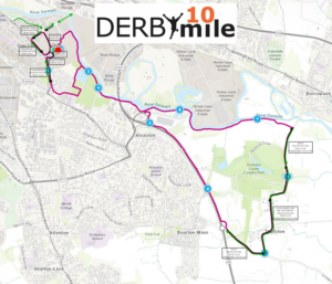
The first part of the race goes on roads around the Pride Park area and later on roads from the A6 Thulston Island through Thulston and Elvaston to the River Derwent track. The road closures are in place for the protection of the runners, volunteers and spectators and they will be kept to a minimum whilst ensuring safety for all. The road closures are as follows:
|
ROUTE/ROADS |
ROAD CLOSURE/RE-OPEN TIMES |
|
Royal Way* |
09:45-10:15 |
|
Derwent Parade from Island 2 to Island 3 (westbound only)* |
09:45-10:15 |
|
Pride Parkway from Island 3 to Island 4 (eastbound only)* |
09:45-10:15 |
|
Pride Parkway from Island 4 to the junction with Pacific Way (southbound closure)* |
09:45-10:20 |
|
B5010 Shardlow Road from it junction with A6 Thulston Roundabout through to Broad Lane B5010/Thulston (eastbound only)^ |
09:30-11:20 |
|
Broad Lane/Ball Lane/Main Road/B5010 to river path junction (River Derwent) (northbound only)^+ |
09:30-11:40 |
* A temporary traffic order has been authorised through Derby City Council.
^ A temporary traffic order has been authorised through South Derbyshire District Council.
+ No waiting cones (supported by a police order) will be placed on roads through Thulston and Elvaston.
Our traffic management operatives, team leaders and marshals will be operating a vehicle gate at Fernhook Avenue and allowing traffic across the route when there are sufficient gaps between the runners but this is closely controlled for the maximum safety of the runners and marshals involved. Access/egress to Elvaston Castle Country Park car park entrance will be controlled when it is safe to do so but it will not be possible to enter or exit this car park across the road closure during the peak flow of runners (approximately between 10:30am and 11:15am).
A resident and business notice will be delivered to those effected on the course around 2-3 weeks before the event.
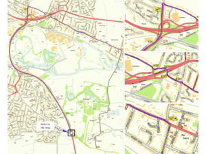
To view a map of the road closures, please click the image below (black arrow = road closed, green arow = road open):
A diversion will be in place on the morning of the race and it can be seen by clicking the image below:
River path access
A temporary river path closure has been authorised between 10:00-12:15 on race day to improve the experience and safety for the runners along this section. The order order has been authorised through Derby City Council. This means that the runners will have exclusive use of the river path during the race.
Derby Arena Car Park – Event Car Park only
On the morning of Sunday 17th November, Derby Arena Car Park will only be used for the Derby 10 Mile race and those parking for the event.
Members/customers of Derby Arena are advised to park in the lower car park from 7am which is located between Pride Park Stadium and Derby Arena – accessed from Island 1 on Pride Park, which remains open at all times.
The main Derby Arena car park will be available for all users from 12.30pm onwards.
We want to hear from you
We are looking for volunteer race crew members to help with event marshalling all across the route and in the Race Village on race day. For further details click here.
Thank you
In anticipation of the Derby 10 Mile event, thank you in advance for your cooperation and support and we look forward to seeing you cheer on the runners on race day!


